Find fishing spot, Catch fish with the Power of Garmin CHIRP
- Made for INDIA with India local languages support.
- Available in 6-inch WVGA color, portrait mode display. Offers a keyed interface with dedicated buttons.
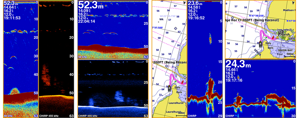
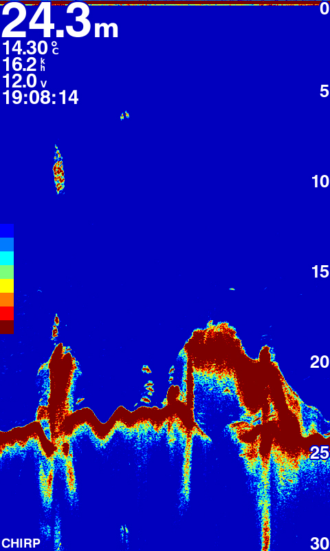
- CHIRP sonar sends a continuous sweep of frequencies ranging from low to high. CHIRP sonar is able to create crisper fish arches with better target separation.
- Built-in 600 W (RMS) CHIRP traditional sonar and CHIRP ClearVü scanning sonar gives a clearer picture of what’s below the boat as a photographic image with representation of objects, structure and fish.
- Compatible with GPS, GLONASS and BeiDou powerful positioning systems what quick and easy to drop up to 12,000 accurate waypoints let you find your way back to your secret fishing hot spots.
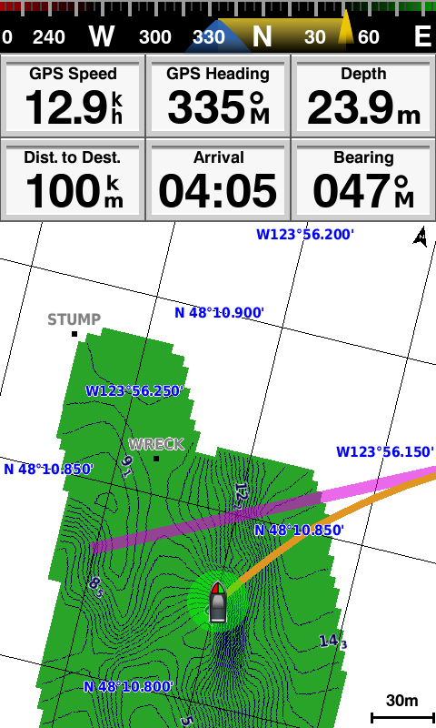
- Free, easy-to-use Quickdraw Contours software instantly creates personalized HD fishing maps is included.
- GPSMAP 585 Plus supports for typical NMEA0183 and RS422 communication within 3rd party sensors and accessories.
- 2 standard SD™ card slots provides expandable memory for accessory map purchases such as LakeVü HD Ultra maps and BlueChart® g2 Vision® charts.
The all-new GPSMAP 585 Plus chart plotter / sonar combo is available in 6-inch display. GPSMAP 585 Plus is offered a worldwide basemap and support all Garmin marine charts also with Asian multi language support and developed the target for semi-commercial fishing market. GPSMAP 585 Plus gives you high wide CHIRP sonar and CHIRP ClearVü scanning sonar capabilities which shows crisp fish arches with excellent target separation and provides clear images of structure below the boat. Supporting GPS, GPS + GLONASS, GPS + BEIDOU 3 kind of positioning modes. New Garmin Quickdraw™ Contours software included lets you create your own maps, with up to 1-foot contour lines, on any body of water.
The Power of Garmin CHIRP
The built-in sonar capabilities of GPSMAP 585 Plus includes CHIRP sonar, the most sophisticated sonar technology available for the fishing and boating public. CHIRP sonar provides amazingly clear target separation and definition because it puts even more energy onto the target than traditional sonar. It also includes sonar-recording capability that coordinates the timing of the sonar return with your boat's position and saves digital information for playback on a computer using HomePort™ planning software. Use the user data sharing cable to share waypoints and routes between multiple devices.
Clearest Scanning Sonar on the Water
Garmin CHIRP ClearVü scanning sonar gives you a nearly photographic image down below your boat. Traditional Garmin HD-ID™ sonar and ClearVü scanning sonar are combined into 1 transducer.
With the Best Maps on the Water Supporting
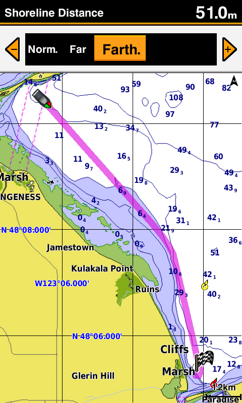
Two standard SD™ card slots provide expandable memory for accessory map purchases such as BlueChart® g2, BlueChart® g2 Vision®. The BlueChart g2 Vision provide exclusive Garmin Auto Guidance, a technology that directs you to your hot spots. Based on your boat’s specifications, Auto Guidance instantly creates a visual path you can follow to avoid shallow water and other charted obstructions.
Quickdraw Contours: Create Your Own HD Maps
Quickdraw Contours is a free, easy-to-use software feature already installed on your GPSMAP 585 Plus. It instantly creates your own personalized HD fishing maps on screen with 1-foot contours. Tailor the maps as needed; you own them. Keep the data for yourself, or share it with Garmin or your friends. No special surveying expertise is required. You just fish while Quickdraw Contours creates maps. There’s no waiting around or sending your files away like other mapping software requires — your results appear instantly.
Compatible with GPS, GLONASS and BeiDou
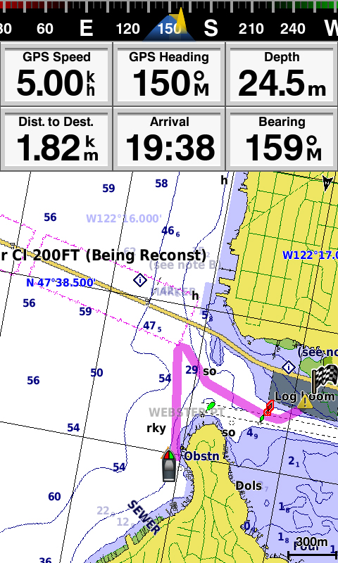
With multi positioning modes supports to GPS, GLONASS and BeiDou three powerful systems. It is quick and easy to drop up to 12,000 accurate waypoints and find your way back to your secret fishing hot spots. Huge capacity memory to help fishermen record danger spot(Mark) and the destination(Waypoint).
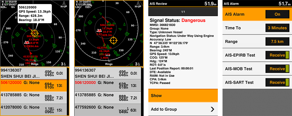
AIS Radar Support
Show you the detailed AIS Radar view and AIS list at the same page. Move the cursor and review particular item on the radar view to see the detail information of highlighted vessel. Drop VRM/EBL and measure distance on the AIS Radar view window and to focus a AIS vessel through the AIS list to see the detail of it.
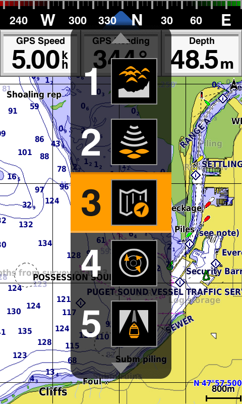
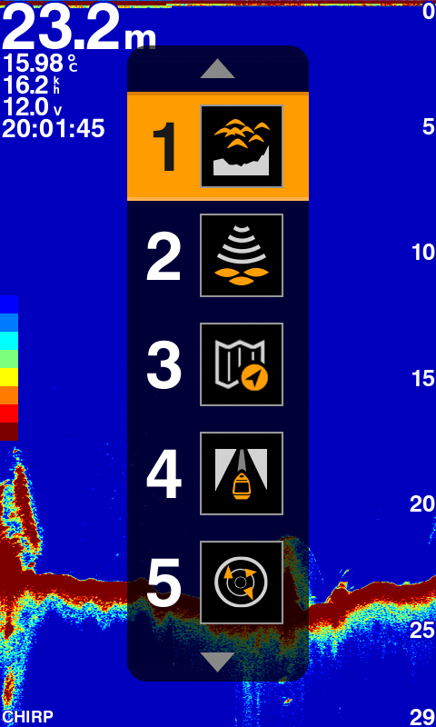
Quick PAGE Sequence
Dedicated PAGE button to have a quick features exchange. Press the “PAGE” button to let user can switch from frequently use feature one by one quickly. With holding the "PAGE" button user can edit their prefer 5 frequently use pages themsleves.
Digital Zoom and Shift Zoom Supporting
Digital Zoom and Shift Zoom features let you control your owned display portion as what you prefer to shows in detailed.
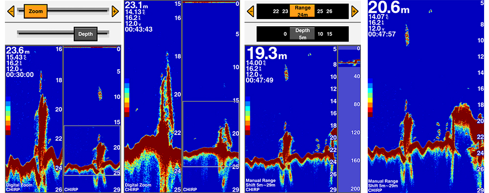
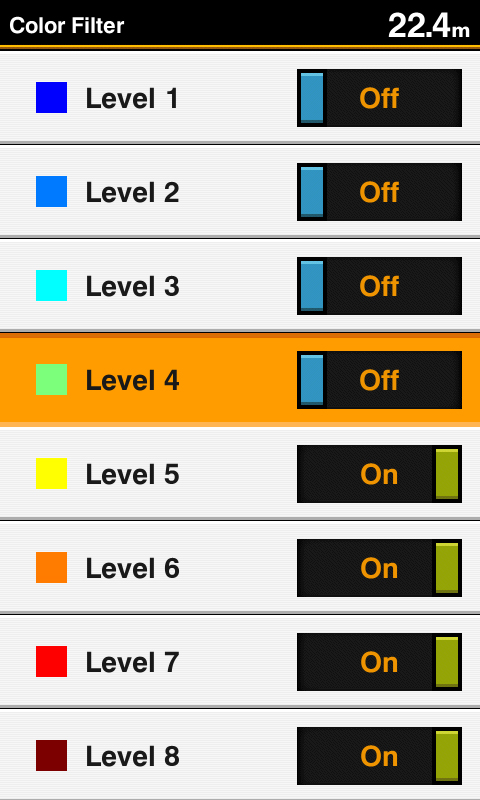
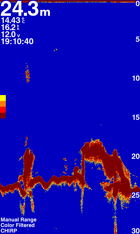
Color Filter for Traditional Sonar Display
8 color levels let users can switch the toggle to turn ON/OFF the specific color on traditional sonar page with their owned preference to show the sonar display.
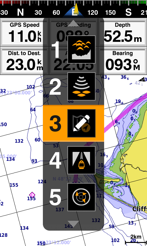
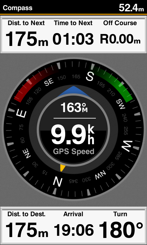
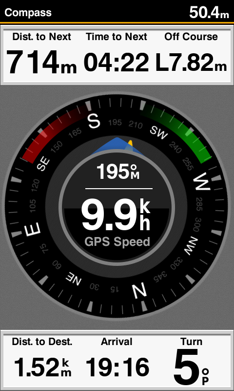
Compass Page to Know COG and SOG at A Glance
Display speed and heading at one page shows to semi-commercial fishermen. They can rely on these information to judge whather the net is full or not while trawling and understand to align the direction of casting the net just at a glanc.
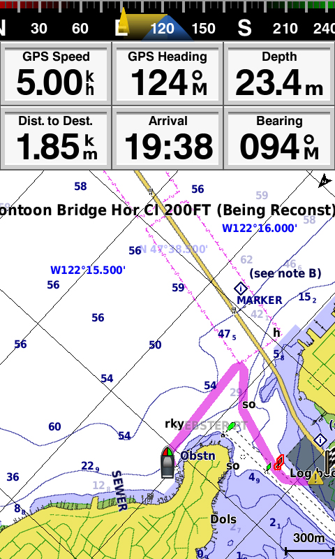
Enhanced Auto Guidance
Just enter the location where you want to go and patented Garmin Auto Guidance technology instantly searches through relevant charts to create a safe, virtual pathway on the display that helps you avoid low bridges, shallow water and other charted obstructions en route.
With enhanced Version 2.0, you have access to more features and capabilities. You’re able to adjust the calculated Auto Guidance pathway by inserting via points at interim stops or landmarks along your desired route. You can easily review hazard points along your calculated path. Other 2.0 enhancements give you the ability to calculate arrival times at any point on your route (great for timing arrivals to correspond with bridge openings and other time-critical events). Better still, you can now save your plotted Auto Guidance paths for future navigation by backing them up on an SD™ card with your BlueChart g2 Vision or LakeVü HD Ultra cartography¹.
GPX Waypoints Transfer
If you have waypoints, tracks or frequently used routes stored on another manufacturer’s GPS product - or on a Garmin handheld device - now it’s easier than ever to transfer those items to your new Garmin chartplotter, via industry-standard GPX software formatting. GPX is an open standard format for GPS data exchange across platforms and applications. With this easy-to-use interface technology, Garmin has taken “no waypoint left behind” to a whole new level of trade-up convenience.
| Cross Products Camparision |
| |
FF 350 Plus
|
FF 650 Plus |
GPSMAP 585 Plus
|
| Display size |
6” color, portrait |
6” color, portrait |
6” color, portrait
|
| Display resolution |
480 x 800
|
480 x 800 |
480 x 800
|
| GPS/GLONASS/BeiDou |
|
- |
-
|
| GPS antenna built-in |
|
- |
-
|
| External GPS antenna support |
|
- |
-
|
| Sonar output power(RMS) |
300W
|
600W |
600W
|
| Sonar Frequency |
50/77/200kHz |
50/77/200kHz CHIRP (Low, Mid, High) |
50/77/200kHz CHIRP (Low, Mid, High)
|
| ClearVü |
-
|
- |
-
|
| Scanning sonar frequency |
260/455/800kHz |
CHIRP 260/455/800kHz |
CHIRP 260/455/800kHz
|
| Chart support |
|
|
• (All Garmin Chart/KMZ custom map)
|
| Quickdraw™ Contours |
|
|
-
|
| Waypoint/Route/Track/Active Track |
|
(12000/200/0 /1) |
(12000/200/0 /1)
|
| IPX7 Waterproof |
- |
- |
-
|
| NMEA 0183/RS422 |
|
- |
-
|
| SD Card |
|
|
(2 standard SD)
|
| Multi-language support |
-
|
- |
-
|