Upbeat Logo
            
 
Home  >>  BHCnav  >>  Nav F30 GPS
 
 
NAVA® F30 GPS


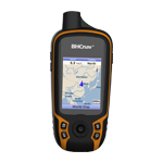
NAVA® F30 is a handheld GPS and GLONASS receiver, with its high-sensitivity, WAAS, EGNOS, GAGAN, MSAS-enable GPS receiver, NAVA® F30 locates your position quickly and precisely and maintains its GPS location even in heavy cover and deep canyons.


NAVA® F30 has an enhanced 2.2", 65K color, 240x320 pixels, sunlight-readable display. Durable, portable and waterproof.


Worldwide basemap preloaded, and NAVA® F30 also supports Vector map (City detail map), DEM map, and Raster map.

NAVA® F30 lets you share your waypoints, tracks, routes in multiple GPS data formats, including GPX, SHP, MIF, CSV, KML, DXF, and TXT via NAVA GPS Office software.

NAVA® F30 is an ideal rugged GPS and GLONASS receiver for a large range of applications from Agriculture, Forest and Biology, Mining, Surveying, Nautical, Hydrographic studies, Engineering disciplines,Geographical (GIS) and Urban information systems,Municipalities and Public works directorates, Electricity, Electronics, Geological studies, Sporting, National Real Estate-land survey directorates, Remote sensing, Public sector and institutions, Planning and First draft projects, Military.


Physical & Performance
Unit dimensions, WxHxD

5.7x12.9x2.8cm

Display resolution, WxH 240×320 pixels, QVGA
Display size, WxH 2.2
Display type Transflective TFT, 65536 colors
Weight:

113g (without battery)

Battery: 2×AA;
Battery life: 2xAA (up to 15hours)
Waterproof: IPX7
Floats

No

High-sensitivity receiver Yes (56 parallel channels)
Interface: USB and NMEA 0183 compatible
 
Maps & Memory
Basemap:

Preload Worldwide basemap

Ability to add maps Yes
Built-in memory RAM: 128MB, Flash Storage: 4GB
Accepts data cards Yes (microSD™ card 32G)
Waypoints/favorites/locations

3000

Routes: 200
Track log: 100 saved tracks, 10000 points
 
Features
Automatic routing:

Yes

Electronic compass: No
Touchscreen No
Barometric altimeter No
Thermometer

No

Camera No
Geocaching-friendly: Yes
Custom maps compatible: Yes
Outdoor GPS games:

Yes

Hunt/fish calendar Yes
Sun and moon information: Yes
Area calculation Area and Perimeter Calculation
Custom POIs

Yes

Picture viewer: No
Google data compatible Yes
AVG Yes
Calculator: Yes
 
PC Support Software
NAVA GPS Office (NGO)

Exchange data with NAVA GPS devices and PC, support CSV, SHP, GPX, MIF, KML and DXF data formats.

Map Generator (MG) Generate customized background map for NAVA with vector MIF or SHP data.


1 . NAVA F30 GPS device

2 . Owner’s Manual

3 . Quick Guide

4 . Neck Landyard

5 . Inspection Card

6 . CD

7 . USB Cable

1 .  Bike / Vehicle Mount

2 .  Vehicle / AC Power Adapter

3 .  USB Cable

4 .  Special Lithium Battery

5 .  Micro SD Card

6 .  Carrying Case

1 .  Worldwide basemap preloaded

2 .  Vector map (City detail map)

3 .  DEM map

4 .  Raster map


Products


HomeAbout Us | Site Map | Blog | Contact Us © Copyright 2009-2019, UPBEAT TECHNOLOGIES, All Rights Reserved