Upbeat Logo
            
 
Home  >>  BHCnav  >>  Nav 600
 
 
NAVA® 600


NAVA 600 takes one of the most popular and reliable GPS handhelds and makes it better.

Redesigned ergonomics, an easier-to-use interface, paperless geocaching and expanded mapping capabilities add up to serious improvements for an already legendary GPS handheld.

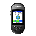
NAVA 600 has an enhanced 2.2", 65K color, sunlight-readable display. Durable and waterproof, NAVA 600 is built to withstand the elements.

Its easy-to-use interface means you’ll spend more time enjoying the outdoors and less time searching for information. It has an upgraded interface yet retains its legendary toughness to withstand dust, dirt, humidity or water.

NAVA 600 adds a built-in 3-axis tilt-compensated electronic compass, which shows your heading even when you’re standing still, without holding it level. Also added is a barometric altimeter which tracks changes in pressure to pinpoint your precise altitude, and you even can use it to plot barometric pressure over time, which can help you keep an eye on changing weather conditions.


Physical & Performance
Unit dimensions, WxHxD

5.7x12x3.4

Display resolution, WxH 240×320 pixels
Display size, WxH 2.2
Display type Transflective TFT, 65536 colors
Weight:

108g (without battery)

Battery: 2×AA;
Battery life: 2xAA (up to 15hours)
Waterproof: IPX7
Floats

No

High-sensitivity receiver Yes (20 channels)
Interface: USB and NMEA 0183 compatible
 
Maps & Memory
Basemap:

Preload Worldwide basemap

Ability to add maps Yes
Built-in memory 128MB
Accepts data cards Yes (microSD™ card 4G)
Waypoints/favorites/locations

3000

Routes: 60
Track log: 50 saved tracks, 5000 points
 
Features
Automatic routing:

Yes

Electronic compass: Yes
Touchscreen No
Barometric altimeter Yes
Thermometer

Yes

Camera No
Geocaching-friendly: Yes
Custom maps compatible: No
Outdoor GPS games:

Yes

Hunt/fish calendar Yes
Sun and moon information: Yes
Area calculation Area and Perimeter Calculation
Custom POIs

Yes

Picture viewer: No
Google data compatible Yes
AVG Yes
Calculator: Yes
 
PC Support Software
NAVA GPS Office (NGO)

Exchange data with NAVA GPS devices and PC, support CSV, SHP, GPX, MIF, KML and DXF data formats.

Map Generator (MG) Generate customized background map for NAVA with vector MIF or SHP data.


1 . NAVA GPS device

2 . Owner’s Manual

3 . Quick Guide

4 . Neck Landyard

5 . Inspection Card

6 . CD

7 . USB Cable

1 .  Bike / Vehicle Mount

2 .  Vehicle / AC Power Adapter

3 .  USB Cable

4 .  Special Lithium Battery

5 .  Micro SD Card

6 .  Carrying Case

1 .  Worldwide basemap preloaded

2 .  Vector map (City detail map)

3 .  DEM map

4 .  Raster map


Products


HomeAbout Us | Site Map | Blog | Contact Us © Copyright 2009-2019, UPBEAT TECHNOLOGIES, All Rights Reserved